Taiwan: Eastern Counties (Yilan, Hualien, and Taitung)
[March & December 2009, November
2015 & 2016, April 2017, March 2026]
![]()

[Source: https://en.wikipedia.org/wiki/Taiwan_Area
]
This page presents photo from eastern Taiwan, a
region comprising the counties of Yilan, Hualien, and Taitung. While the
western side of the island is home to a vast plain and major cities, the east
is where its central mountain range, which stretches from south to north and
boasts several peaks exceeding 3000m, plunges abruptly into the East China Sea.
These two sides could not be more different.
Note: Photos from a trip to the island of Lanyu, which is part of the Taitung
county, are presented in a separate webpage (here).
Yilan County (宜蘭縣)
This is the northernmost county featured in this
page. It is located east of New Taipei City.
Turtle Island (龜山島):
Located 10km off the coast, this island, shaped
like a floating sea turtle, is Taiwan's only active volcano.
The island seen from a boat.

[March 2009]
Wufengqi Waterfall (五峰旗瀑布):
This multi-tiered waterfall is located
in the mountains, about 3km northwest of Jiaoxi
Township (礁溪).
|
|
|


[March 2026]
Linmei Shipan Trail (林美石磐步道):
Located 3.5km west of Jiaoxi Township, this
hiking trail runs alongside a pretty river.
|
|
|


|
|
|


|
|
|
|


[March 2026]
Jiguang temple of Ling Jiou
Mountain (靈鷲山寂光寺):
This temple is located in
the outskirts of the Jiaoxi Township, on the shores
of Longtan Lake. It was here that, in the late 1970s,
Master Hsin Tao (心道法師), founder of the Ling Jiou Mountain Buddhist Society, withdrew to devote himself
to meditation and rigorous ascetism.
Buddha statues in the
monastery precinct They were carved in white jade by artisans in Myanmar. The
statue of the Reclining Buddha is 10m long and weighs 60 tons.
|
|
|


[March 2026]
Hualien County (花蓮縣)
Qingshui Cliffs (清水斷崖):
These plunging coastal cliffs are located approximately 27km north of
Hualien City (花蓮市).


|
|
|


[November 2016]
Taroko Gorge (太魯閣峽谷):
Situated roughly 20km north of Hualien City, this
gorge (which stretches for 19km) is part of the Taroko
National Park. It is one of the most spectacular natural destinations in Taiwan
accessible by car.
Views of the Taroko
gorge. The marble walls of the canyon were carved by the Liwu
river.
|
|
|


|
|
|
|


|
|
|
|


- Right: Warning sign posted at the
entry of the Shakadang trail (which is, in reality,
an easy side hike branching off from the Taroko
gorge).
- Left: View of the river along this
trail.
|
|
|


[December 2009]
Mural in a
restaurant at the entrance of the Taroko gorge. It depicts
an aboriginal hunter and his son in the local mountains.

[November 2016]
Xiangde temple (祥德寺):
Built in 1968, this Buddhist temple is located at
the end of the narrow section of the Taroko gorge.
Statue of Bodhisattva
Ksitigarbha (地藏菩萨), the Buddhist Lord of the Underworld,
known for his vow not to achieve Buddhahood until
all hells have been emptied. He is also regarded as the guardian of
children. He is known as Jizo in Japan. This statue stands 11m tall.
|
|
|


[December 2009]
Statue of Guanyin (觀音), the Bodhisattva of infinite compassion
and mercy.

[December 2009]
The
seven-story Tianfeng Pagoda of the temple.

[November 2016]
Walami Trail (瓦拉米):
Beginning 15km east of the
small town of Yuli (located in the East Rift Valley), the Walami
trail is one possible access to the inner part of Yushan National Park and its
extensive network of trails. Its initial section does not require a permit, yet
offers a good out-and-back hike.


|
|
|
|


|
|
|


|
|
|


[November 2016]
East Rift Valley (花東縱谷):
This valley is a
180km-long narrow depression stretching from Hualien City to Taitung City, between
a coastal mountain range and Taiwan's central mountain range. It lies over the
collision zone between two tectonic plates.
View over the East Rift Valley from the
Sixty Stone Mountain (六十石山).

Rice fields in Chishang
(池上) in the southern part of the East Rift
Valley, located in the Taitung county.

Restaurant serving
breakfast near Chishang.

[November 2015]
Taitung County (臺東縣)
Sanxiantai (三仙台):
This coastal landmark is located
50km northeast of Taitung City (臺東市). It consists of rocky islets of
volcanic origin, connected to the mainland by an eight-arched bridge that
evokes a sea dragon. Its Chinese name, 三仙台, means ″Towers of the Three Immortals″. It derives
from of the presence of three main islets that are likened to three legendary
Taoist deities known as Immortals (″Xian″), who lived until a very
old age by achieving harmony with the Tao.

Fugang (富岡) harbor:
Located 6km northeast of
Taitung city center, this harbor serves both as a fishing port and as a
departure point for ferries serving Lanyu Island and
Green Island.

[April 2017]
Taitung City (臺東市):
This is the
main city (pop. 103,000) south of Taiwan‛s East coast. I found its inhabitants
extremely friendly and definitively more laidback than in the rest of Taiwan.
Photos taken while landing at Taitung
airport.
|
|
|


[November 2015]

[April 2017]
In Liyushan
Park (鯉魚山公園). Left: People playing mahjong under a
banyan tree. Right: Pagoda (龍鳳寶玉塔).
|
|
|


[November 2015]
Paper lanterns along the old railway
near Liyushan Park.
|
|
|


|
|
|


|
|
|


[November 2015]
In the central market.
|
|
|


[November 2015]
At the Peinan archaeological site. Located next to Taitung's train
station, this prehistoric site was discovered in the late 19th century, but
most of the excavations were done in 1945 and later. They yielded a large
number of jade and pottery artifacts, as well as slate coffins (see photo
below, on the left). According to anthropologists, tooth extraction was a
common practice of the Peinan culture: upon reaching
adulthood all individuals had their upper canines and lateral incisors
extracted from the upper jaw (see the photos of the renderings posted in the
site, below).
|
|
|


|
|
|


[November 2016]
″Buddha‛s head″
fruits, also known as custard apples, a specialty of the Taitung region, here
in a plantation near Taitung.

[November 2015]
Pottery studio of Zudweyi Ruvaniyao:
It is located in a small
narrow canyon at the end of Xinbanjiu Road, in Beinan Township, north of Taitung City. Zudweyi Ruvaniyao, a local artist, is a member of the indigenous Paiwan people of
Taiwan. Numbered approximately 100,000, this indigenous group is the
second-largest of Taiwan.

One of Zudweyi Ruvaniyao's apprentices.

Pool in the garden.

[November 2015]
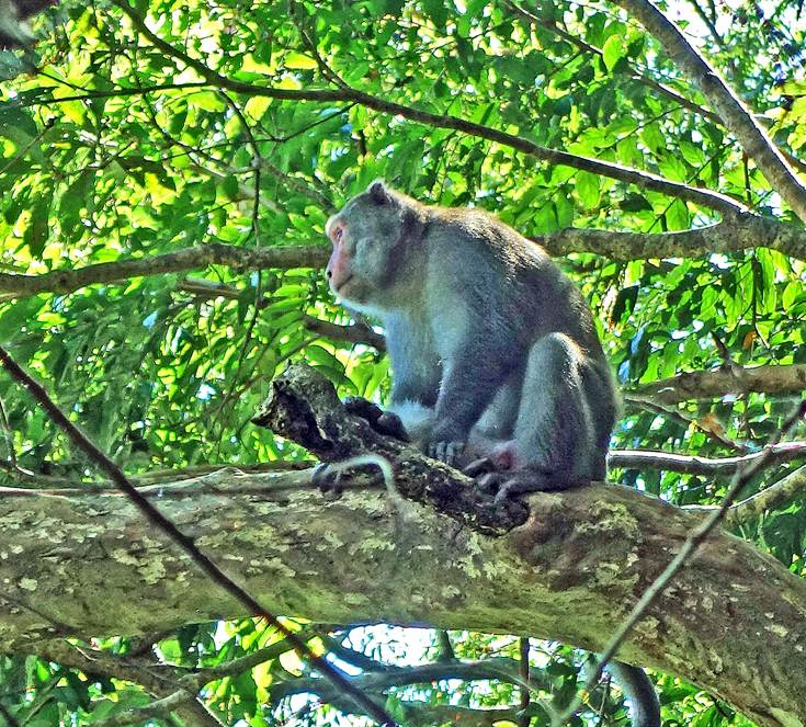
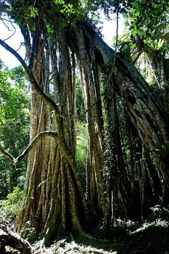
Zhiben National Forest Recreation Area (知本國家森林遊樂區):
It is located in the mountains above the Zhiben Hot Spring village, about 20km southwest of Taitung
City.,
View from the Zhiben
forest toward the east.

Taiwan macaques in Zhiben
Forest.
|
|
|

Banyan trees in Zhiben
Forest.
|
|
|
|
|


[November 2015]
![]()